Strong Thunderstorms to Impact Portions of the Parish
Published 10:21 am Friday, June 13, 2025
|
Getting your Trinity Audio player ready...
|
The Washington Parish Office of Homeland Security and Emergency Preparedness posted the following warning
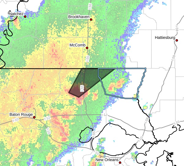
Washington LA-St. Helena LA-Northern Tangipahoa LA-
947 AM CDT Fri Jun 13 2025
…A STRONG THUNDERSTORM WILL IMPACT PORTIONS OF SOUTHEASTERN ST.
HELENA, NORTHWESTERN TANGIPAHOA AND NORTHWESTERN WASHINGTON PARISHES
THROUGH 1045 AM CDT
…
At 947 AM CDT, Doppler radar was tracking a strong thunderstorm near
Greensburg, moving northeast at 30 mph.
HAZARD…Winds in excess of 40 mph and pea size hail.
SOURCE…Radar indicated.
IMPACT…Gusty winds could knock down tree limbs and blow around
unsecured objects. Minor damage to outdoor objects is
possible.
Locations impacted include…
Greensburg, Amite City, Kentwood, Roseland, Osyka, Mount Herman, and
Tangipahoa.
This includes Interstate 55 in Louisiana between mile markers 48 and
66.
PRECAUTIONARY/PREPAREDNESS ACTIONS…
If outdoors, consider seeking shelter inside a building.
&&
LAT…LON 3068 9060 3073 9073 3100 9056 3100 9013
TIME…MOT…LOC 1447Z 224DEG 27KT 3076 9061
MAX HAIL SIZE…0.25 IN
MAX WIND GUST…40 MPH